Surface Geology
SURFACE GEOLOGY OF THE PROPERTY
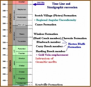
Within the claims, the only rocks that outcrop along the scarps and rivers are the massive anhydrite of the White Quarry Fm., which is the basal member of the Windsor Group. West of the boundary of the claims is a vague shallow syncline plunging northeast. Throughout the claim is a 70° S dip east-west cleavage in the host White Quarry Fm. anhydrite beds which strike west-southwest and dip 5º to the north.
Outside of the claims within 0.5 km, along Barkhouse Creek, the White Quarry Fm. unconformably overlays the Cheverie Fm. The Cheverie Fm. unconformably covers the upper member of the Horton Bluff Fm. Where the Cheverie Fm. dips at about 5° to the east, while the Horton Bluff Fm. dips 10° to the east. The dip seems to steepen further to the northwest along the creek bed, as the section ages into the middle member and returns to the 15° dip when the lower member is reached near the headwaters of this creek.
Within about a 2.5 km radius of the claim block to the south and northwest, the country rock is granite. Due west, granite outcrops about 3.2 km up the valley.
The bedrock surface is covered with extensive glacial deposits. The overburden varies from 2 to 3 m on hills within the claim to 25 m in the levees meadows of the eastern area. This overburden is mainly glacial alluvial deposits from eastern source areas.
On the western side of the claim, the overburden thickens to as much as 20 to 25 m. On the west of the claims, the overburden is esker gravels and sands. Peats are preserved near the claim’s boundary and exposed in the riverbank. The eskers, transported into place by glaciation from the south, these are lapped by the eastern-sourced glacial alluvial deposits.
SUBSURFACE GEOLOGY OF THE PROPERTY
Basis of database
Initial interest in the claim area came about as the result of an unrelated research project commenced in April, 1994. This project was focused on the stratigraphy and paleoecology of the Minas Basin region. The observations noted here are based on an accumulation of data over 68 in the field days and 16 laboratory days.
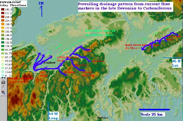
Field mapping and sample analysis of the area tens of kilometers to the north and northeast of exposed Horton formation from where the claim blocks were subsequently staked revealed data that pointed to the current source directions of the sediments placed on the Avonport Peninsula. A combination of sedimentary and paleontological variables as
- Rose diagrams for the angles of imbrication, scour marks, lineations and cross stratification revealed a flow source area from a south to southwest direction.
- Work in the southeastern limits, both in the basin and on the southern highland, displayed a southwestern current flow truncated to the west of the claim blocks.
- The tabulation of species identified their bed locations and abundances.
- Neutron activation analysis of 60 + elemental abundances including rare earth elements from over 50 sites in the region
- Petrographical thin section prepared and microscope work done on 40 sample sites.
- After the claims were staked.
- To date over 13,370 m of drill core has been logged and integrated into the field work (TME drilled about 9,800 m and the rest was drilled by previous companies of which the core was located and integrated into TME’s Time and Facies domain sequence stratigraphic template based on 18 holes by TME + 10 holes by Saarberg.)
- Taken from the borehole core were 290 segments of split core for multi-elemental assay (1/2 core always remains in the box, if need be for replication) This time always including gold, tungsten, copper, arsenic and silver.
- All lower sections were scanned with radiation detectors (none found) and UV fluorescence (for zircon and scheelite)
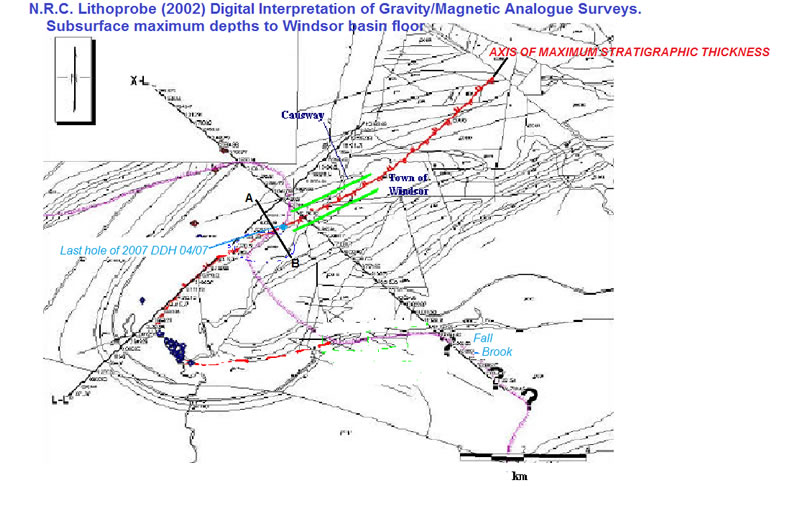
- Also obtained and integrated is the NRC Lithoprobe’s regional geophysics data and interpretations that fortunately was focused to its highest resolution centered on the close near center of the claims.
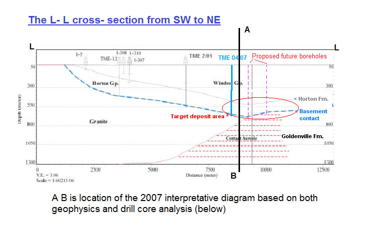
The L-L cross section provided by the National Research Council’s Lithoprobe interpretation is:
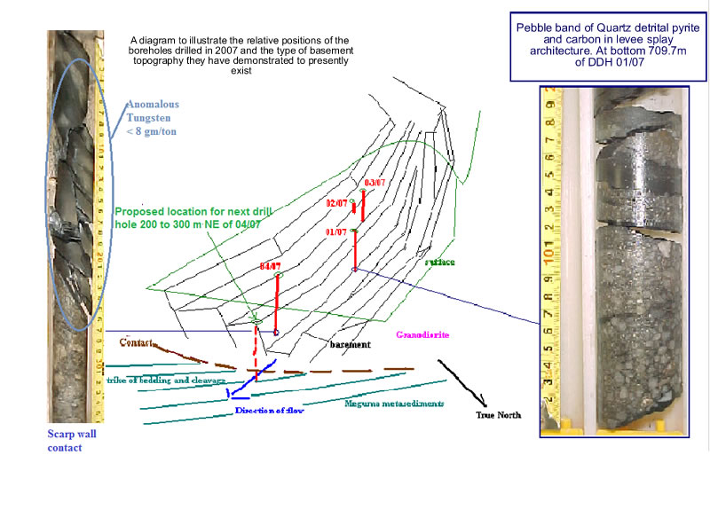
All of this is fully recorded integrated and interpreted in a report that will require a confidentiality agreement to be signed and will be made available only to investors or their technical advisors.
RESOURCE AREA
In all placers or paleoplacers (fossil placers) the deposit originates and gets placed “its provenance” is a rock body with a rich source of gold (or other placer metals like tin, tungsten, platinum) that gets broken down by weathering and is eroded via water, ice or wind to its site of deposition. There are dozens of places on earth with quartz pebble conglomerates of various ages but they have no gold.
There are several key ingredients required for placers to form 1/ a source area that is metal rich 2/ erosion of it happening at or just post the lode forming time, and 3/ an oscillating land and sea tectonic regime during and post the “gold deposit forming time”.
When considering other known placer and paleoplacer regions the paucity of production from the source lode veins when compared to the placer field production is the norm. The following fields are each unique with differing paleogeographys, therefore there is no such thing as duplication, but the trend will be evident.
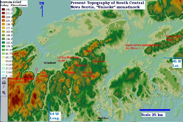
The Klondike camp near Dawson Yukon has produced over 11 million troy ounces from its placer workings. Most of the bedrock is a greenish white schist with abundant stringer veinlets of quartz known as the Klondike schist.
There are two known lode mines in the source areas of the gold in the placers within this schist, the Lone Star mine and the King Solomon mine. The Lone Star produced about 2500 ounces on 7,700 tons blocked out, and the King Solomon produced 11,000 ounces on 35,000 tons blocked out.
The Bendigo goldfield of the State of Victoria in Australia, has folded saddle lode veins which have produced about 8 million ounces. Before the lode veins were found in the late 1860s, Australia’s gold rush began in 1854 on the placers affiliated with this source area, the records are unreliable but 50 million ounces is considered a conservative figure.
The Otago goldfield of the Southern Alps, South Island, New Zealand may be most similar to the Meguma/Horton in geographical variables. The mesothermal lode veins in the Otago schist have produced about 2 million ounces. The placer field so far has yielded about 22 million ounces and is still in production.
Finally the Witwatersrand. The source of the gold in the pebble conglomerates of the Rand has long been established to be the flanking Barberton Archean complex. Some forty mines on the known lode veins in the Barberton hills have yielded just over 7.5 million ounces, to date the Rand has produced 1.4 billion ounces and will still be a prolific producer for decades to come.
To Summarize:
| Location | Lode | Placer |
| Klondike | 14,000 | 10,000,000 |
| Australia | 8,000,000 | 50,000,000 + |
| New Zealand | 2,000,000 | 22,000,000 + |
| South Africa | 7,500,000 | 1,400,000,000 |
| Ghana | 10,000,000+ | 160,000,000 |
| Castle Frederick | 115,000+ | ? |
Further there is already exactly such an ex producing mine just 70 km away within the same host rocks of the same age. Therefore it can provide us a more relevant measure of the ratio of enrichment for this area’s place and duration of placer formation. The Gays River Coldstream workings moved over 48,000 cubic yds and fed a mill about 12,000 tons of hand sorted quartz pebble conglomerate are, this at its most conservative estimation would imply not less than 10,000 ounces but very likely more. If it was 20,000 ounces then operations would have been larger and gone on for a longer period so we can reasonably propose more than 10,000 but very unlikely to be more than 15,000 thus 12 to 15 thousand ounces is most probable. The source area was note to be the veins that pepper the Wittenburg Mountain that flanks this paleoplacer and both Malcolm and Boyle of the GSC determined this. Collectively these lode veins produced about a hundred ounces, thus the ratio would be 120 to 150-fold enrichment. Therefore where our source area can be conservatively estimated as the northern flank of the Rawdon-Uniacke hills with an historic lode vein production of 115,000 ounces it is reasonable to expect a ? 10 million ounce paleoplacer deposit.
It is the results of the previously mentioned accumulated surface and subsurface geological and geophysical database. The stratigraphy succession of the filling of this basin is the following flow trends for how these Devono-Carboniferous basins were filled is illustrated below.

