NS Geology
REGIONAL SETTING
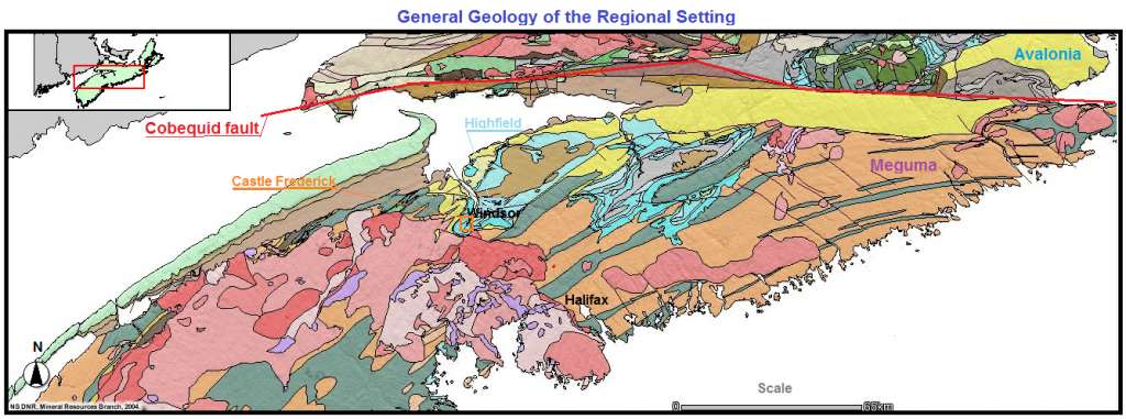
Both projects are located in the southwestern portion of the Windsor sub-basin. This sub-basin is part of a series of basins (the Windsor, Colchester, Shubenacadie, Musquodoboit and St. Mary’s sub basins) that were formed during the middle Devonian times when the continental blocks that made up the Pangea super continent were in the process of converging. Inflows of continental sediments to these basins were augmented by a number of marine advances. The Windsor sub-basin’s northern boundary is the Cobequid fault. This strike–slip wrench fault delineates the splice between two different paleogeographical provincial domains, Meguma and Avalonia.

To the north of the Cobequid fault is the Avalonian Appalachian province. Its rock suites indicate that Avalonian geology is the result of its being in an active margin during closure of the Iapetus Ocean (subduction occurred under Avalonia rocks were emplaced between the early Cambrian and late Silurian time – 570 – 415 million years ago (m y a))
On the south side of the Cobequid fault is the Meguma province of African origin. The Windsor sub-basin’s floor and southern wall is composed of this province’s metagraywackes and slates that are in places intruded by granitic rocks, especially on the southwestern portion of this basin. The location of these projects is in this southern rock belt.
AUTOCHTHONOUS SUCCESSION
PRECAMBRIAN to LOWER PALEOZOIC BASEMENT (Core Platform)
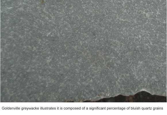
The Meguma basement is composed of greywacke and shales that have been metamorphosed.the origin is from a continental source area to the south of the present terrain. Bedding features suggest an off-shelf to edge of shelf marine site of deposition. Meguma is the result of the coastal shelf outwash of the Varangian glaciation’s retreat. Its components’ source is southwestern Africa. (P. E. Schenk, 1997) It is this metasedimentary group that is the basins’ floor underlying the area of study.

On the northern flank of this metasedimentary terrain there are volcanic sequences that are blanketed on their flanks by quartzite, siltstones and shales. The shales have graptolites and are blanketed by tuffs in some areas. The Meguma domain’s geological condition changed during the post Ordovician. These Silurian deposited sediments reflect a shallow marine site of placement. There is a tiny inlier of this unit in the Rainy Cove area along the coast.
MIDDLE PALEOZOIC INTRUSIONS
In the middle to upper Devonian is a period of metamorphism and deformation of the basement, granitic intrusives were later emplaced. These intrusives are medium to coarse grained crystalline rocks. The feldspars hold perthitic textures, which indicate that granitization, occurred at a depth of at least 7 km. under the Devonian surface. By 374 m.y.a. the first plutons crystallized and mark the beginning of a thermal pulse period during the mountain building known in the literature as the Acadian Orogeny.
[ a hornblende granodiorite ]
MIDDLE to UPPER PALEOZOIC COVER
In the upper Devonian time zone, the basins area became a catchment for the weathered debris from the southern highlands. The sediments deposited in this Windsor basin both thicken and fine northward, the pile in a north-south cross section is asymmetrical. In the south, these posts Devonian sediments onlap onto the north dipping metamorphosed greywacke/slate peneplain.
The Horton Bluff Fm. and disconformable Cheverie Fm. (Horton Group) cover the Meguma basement by angular unconformity. The Horton Bluff Fm. is continental debris carried, during the late Frammenian to late middle Tournasian rock time stages, by rivers and creeks that flowed from the southern platform area north into the basin. The formation is composed of purplish gray basal conglomerates, covered by brownish gray sandstones, overlaid by bluish gray shales. Cheverie Fm. is the distinct upper member of the Horton Group and composes only about 10% of the Group. This formation is dominated by beige arkosic sandstones and some conglomerates, covered by more arenaceous shales of the overlying Macumber unit’s composition and texture suggests a prolonged sub aerial exposure.
[ Bluebeach shales ]
[ arkose ]
Covering the hiatus are deposits that were placed by a succession of marine transgressions, which occurred throughout the basin in Visean time stage. Six major cycles of advance and retreat of seawater into this bay took place. Five of these cycles occurred in relation to a predominantly marine ecology and are collectively known as the Windsor Group. During the advance of the sea each cycle placed in a conformable order marine limestones and minor clastics from the slopes. Anhydrite, gypsum and salt were laid down in the marine retreat period.
[ Limestone ]
[ Anhydrite ]
The sixth cycle defined as the Canso Group occurred near the base of the Namurian time stage, it exhibited some marine influence but was predominantly continental influx. IThe attitude of the continental sediment, along with the type of marine deposits, suggests a rapidly changing topography. The top of the Canso Group was sheared by wide spread angular unconformity, which is an indication that there was an extended erosional exposure before the Pictou Group sediments were emplaced. At the close of the Namurian (Kontak et al, 2000) recorded that the mineralization in faulting of the alkali basalt injection cut through the dykes on the Mac Isaac occurrence on Cheverie road six km north-northeast of the Highfield, tying mobilization of mineralizing fluids to the negative pressure of the post extensional tectonics regime.
Overlying the Windsor and Canso Groups in the basin is the Scotch Village Fm., which is composed of fluvial and swamps sediments dating to the Westphalian time stage. This formation is classed as the Pictou Group, and is the residue of a Deltaic Forest Moor and Reed Moor environment.
LOWER to MIDDLE MESOZOIC
In the late middle Triassic period, a new and smaller basin was formed between the Cobequid fault and Avonport. This narrow, elongate valley was formed due to a failure of the super continent to split. These blocks – faulted rift valleys were sites of volcanic flows and natural traps for sediments. The rift valley of the Fundy was one of a line of valleys formed near the Atlantic edge of the Appalachians in the period before the Atlantic Ocean appeared inside the central interior of a super-continent. However this was prior to any Atlantic ocean and during this Karnian stage time, it is noted that the absence of kaolinite along with the preserved unaltered feldspars in conglomerate cobbles suggests mechanical weathering without chemical weathering as the mechanism, indicating a semi arid climate. These sediments, which were deposited in this valley, were developed from weathered and very iron rich rocks proximal to the steep-walled valley. In that semi arid climate these sediments were structured subject to flash floods and ephemeral lakes. These Triassic red-bed sediments and volcanics overlie with a distinct angular unconformity the Windsor sub-basin’s Carboniferous deposits.
[ Angular Unconformity between Carboniferous and Triassic ]
[ Triassic red beds conglomerate ]
The youngest bedrock exposed in this region are the outcrops of the lower Jurassic Scots Bay Fm. This formation is composed of limestones, cherts and siltstones, restricted to the central area of the Fundy basin, illustrates the arrival of marine conditions in a warm climate in these times.
UPPER MESOZOIC
Of interest to this regional geology is the recent discovery, under the glacial drift, of an early Cretaceous basin that contains a large deposit of silica sands and kaolinite clays. This deposit was placed by a drainage system that originated in the west-northwest. The deposit exhibits an increase of clay content in the eastern end of the basin, its grain size grades coarser on the western side of the basin. Along with fining upwards, and cross bedding this deposit has the characteristics of placement by fluvial action. The abundance of sericite with the kaolin illite assemblage suggests a hydrothermal origin for these clay deposits. Also the presence of preserved pyrite and magnetite both as a micron coating on clay grains and as an interstitial particle component in the matrix with kaolinite and illite re-enforces the hydrothermal origin and further suggests short transport. This basin is 22 km east-southeast of the Meguma metasediment highlands that form the south wall of Windsor Avon valley.
QUATERNARY
In Nova Scotia, glaciation has left deposits since the Illinoisan stage. However, glaciation also eroded and scoured away the remains of a tropical world. There are no deposits, which date from the Illinoisan stage near the locality of this study, the nearest deposits from this earliest glaciation are just north of Bridgewater. This glaciation’s direction of scouring transported its load southeast, off the land and on to the shelf in phase I (220,000 – 60,000 y.a.). After phase I’s ice advance and retreat, a younger glaciation, phase Ib (60,000 – 35,000 y.a.) overprinted a scour direction which deposited its load due south, off land along the coast. The last glaciation, which left no deposits, but scraped this district, was phase II (32,000 – 25,000 y.a.) its direction of advance deposited debris south-southwest off land.
The most recent deposits of this study area are the unconsolidated glacial deposits emplaced in the late quaternary. Ground moraine tills, esker sands and gravels, alluvial sands and muds fining upwards, and marine gravels, sands, silts, clays, and peats in the salt marsh areas are all formed in this region by glaciers.
Glaciation became a depositional factor in the Windsor sub-basin region during the late Wisconsinan stage. The ice flow directions of phases III and IV were the control, which defined these deposits. The phase III ice advance was the last glacial event to mark the area (17,000 – 15,000 y.a.) and was a northward flow centered on an axis to the south, parallel to the Beach Hill/Pleasantfield line. This flow deposited the Hants Till that blankets most of this region. This Till is composed of debris abraded by glacial factors from the south.
The phase IV ice advance was the last glacial event to mark the area (13,000 – 10,000 y.a.) it deposited debris abraded from the localities due east of this region and placed deposits as, the Rawdon Till, which are due to a westward flow.
STRUCTURAL GEOLOGY OF THE AUTOCHTHONOUS SUCCESSION
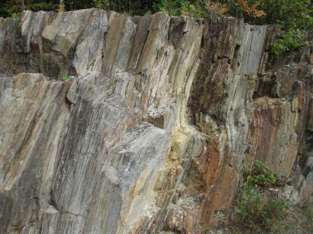
The Cambro-Ordovician, greywacke and slates that form the walls and basement of this region, display both deformation and metamorphism. The deformation has produced a northeast-southwest trending axis for the folding that has developed a set of upright parallel synclines and anticlines. These folds plunge towards the southwest. In this region the metamorphism of the Meguma is of the Barrovian Biotite zone, or middle greenschist facies. The granites that have intruded this greywacke/slate pile display a parallel fabric of their feldspar and biotite phenocrysts only within a close proximity to the pluton’s margins. In the Windsor region, this foliation is of a general east-west orientation.
The rocks of Horton, Windsor and Canso Groups have been faulted and folded extensively but show no significant metamorphism, except in one area, Rainy Cove where foliation turns the shales phyllitic with white micas. These sediments display no contact metamorphism with the granite. This means that these sediments postdate the granite’s placement and exposure. These rocks, besides being exposed to the northeast-southwest trending normal faulting, also record north-south, east-west, and northwest-southeast trending faults as well as shears. The east-west normal faults display offsets that seldom exceed 200 m. Some of the north-south faults have offsets in excess of 800 m. The northeast trending faults and shears are in the range of 500 to 600 m. The northeast shears display brecciated zones that show widths that vary between 200 to 300 m. The folding of these strata has produced upright synclines and anticlines. The axis of these folds aligns northeast southwest, and plunge towards the northeast. The structural deformation becomes more intense to the north of the Noel to Gaspereau Mountain line. Thrusting with near overturn folds, recumbent folds and drag faulting is common.
[ Recumbent fold at Rainy Cove ]
Westphalian rocks do not display deformation, they are indurated, intact, right side up, becoming progressively younger as they approach the surface. These strata are tilted by »10° towards the south and are affected by northwest trending normal faults whose displacement is not extensive, rarely exceeding 100 m offsets.
Rocks of Triassic age and younger are not deformed or tilted and are right side up, they also do not display offsets from the northwest-southeast faults. The older wall rocks do display offsets due to the northwest trending normal faults.
[ Angular Unconformity tilting about 10° down to north ]
THE ALLOCHTHONOUS SUCCESSION
The three units identified as being transported blocks {klippes} (these rock bodies were formed in a different location from where they now are, see Map #2) were moved into place by thrust sliding during a major tectonic event known as the Alleghenian Orogeny between 318 – 315 m.y.a. 315 million years ago is viewed as the time of pressure shift, this coincides with the dating of both the Tobeatic Shear and the alkali basaltic dykes which intrude near Walton and Cheverie Both of these features suggest a change from compressional to extensional tectonics. The two sedimentary bodies both exhibit a disconformable brecciated floor contact, and all bodies are exotic to their host stratigraphy.
SOUTH AVON-VAUGHN GNEISS INLIER
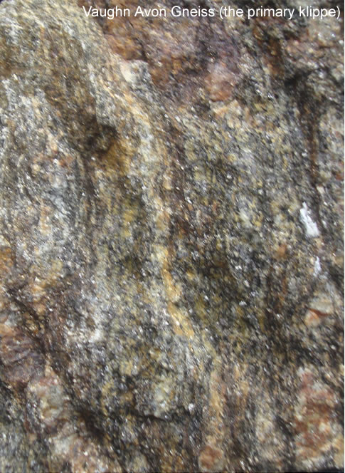
In the South Mountain peneplain within 4.5 km of the Minas lowlands up the South Avon River is a greenish gray to blackish gneiss outcrop that extends 2.5 by 6.5 km in size. This rock body has a drop shape in its outline, vaguely similar to a door stop wedge form. The gneiss is not intruded by the underlying granites and displays the complex overprint fabric of multiple deformations. This gneiss body’s deformations’ intensity and axis of orientations are not found anywhere else in the Meguma terrain. To the northern end of this formation the body displays a schist fabric in a north-northeast to south-southwest orientation. A closer inspection reveals this fabric is due to differentiated layering from an overlay of a west-southwest S1 with a northeast S2. Several kilometers to the south in larger outcrop there appears to be bedding with a southeast strike dipping to the northeast, which is an S3 gneissic layering. This S3 deformation contains the prevailing north-northeast schistosity. Moving further south towards the broad blunt southern boundary of the gneiss the schistosity changes to an east west orientation indicating an S4 overprint. Also noted in this S4 area are porphyroblasts of andalusite, which indicates a higher degree of metamorphism near the southern boundary.

To the southwest of the gneiss is the Leminster Inlier. This metasedimentary inlier is over 14 times the size of the gneiss unit, is elongated and oriented in the same structural strike as the rest of the Meguma terrain. This Meguma inlier greywacke and slate body displays the same metamorphism and deformation pattern present in the rest of the Cambro-Ordovician basement surrounding the granitic intrusion. This deformation pattern seems to be composed of two phases of deformation. The predominant deformation is a west-southwest to east-northeast hinge axis (S2) that overprints an earlier northwest to southeast axis (S1) deformation. The Leminster Inlier is an in-situ roof pendant, a remnant of the original blanket thatcovered the crystallizing granitic batholith.
This gneiss body was the target of a ground gravimetric survey. The profile interpretation of that 1996 field survey suggested at depth a wedge shape to the gneiss, thickest in the wider southern part and shallowest in the narrow northern part. This gneiss body is intruded in the northern end by two small dykes, these intrusions do not cross the contact into the surrounding granites. The apalite dyke composition, of leucogranite suggests an upper Namurian age, as most of the main leucogranite batholith is middle Carboniferous. There are two other minor occurrences of the same rock to the southeast, these are identical to the main gneiss body except they are not intruded by any dykes.
THE BENJAMIN MILL OUTLIER
The Benjamin outlier is composed solely of the lower Horton sediments. This wedge extends for 5 km in north-south alignment, it is at its most broad in the north extending east-west about 2 kms, and narrows down southward to under 0.5 km in broadness. It is relatively flat lying to the underlying granite. The contact is composed of a fragmented granitic breccia, which has a matrix of the same mineral composition as the granitic fragments. It was observed in the contact 1 km south of the Mines road quarry that the quartz fragments in the basal breccia display striations and a preferred fabric in an east-west orientation. Also to be noted the basal breccia micas hornblendes and feldspars are present and unchanged into clay minerals.
The units above the breccia are composed of sandstones and gritty siltstones with abundant carbonized floral fragments,. The beds are striking to the northeast southwest dipping between 5 to 10° down towards the east. These beds fine upwards and their coarse sandstone units display cross bedding which suggests an alluvial regime of deposition. These sandstone beds display in their orientation of fore sets that they are right side up and the depositing flow was from the east.
This outlier lies just to the south of the Fletcher-Fairbault fault and just to the east of the Colpitt Hill fault. The Fletcher-Fairbault fault has a westward displacement and the Colpitt Hill fault has a southwestern displacement. In the context of its position and its breccia granodiorite contact this outlier’s present location appears due to tectonic variables.
MAHONE BAY – CHESTER OUTLIER
In the Mahone Bay-St. Margarets Bay area that is 31 km south of the South Avon-Vaughn gneiss is a group of outliers composed solely of lower Windsor Group carbonates hugging the coast. Geophysical surveys have integrated the 13 outlier locations into four distinct sheets and four isolated fragments. These units are indeed sheets, which extends from Chester Basin down to Second Peninsula and thins southward. Seismic surveys found that the unit obtained a thickness of about 5 to 10 m but then abruptly disappears going further south.
The unit is composed of a single rock time unit the lower Gays River Fm. This formation is composed of massive gray dolostone, which is very fossiliferous as to be described in the literature as biohermal. It’s hard intact gray blue beds strike north-south and dip 5° to 7° down to the east. This unit is in a disconformable breccia like contact with the underlying granite. The breccia contains both angular and rounded Gays River, Goldenville and granite fragments in a pulverized Gays River matrix.
Both the Benjamin Mill and Mahone Bay-Chester klippes do not exhibit any deformation in their rock fabric unlike the autochthonous Horton group rocks. In consideration of the above observation it can be inferred that the South Avon-Vaughn Gneiss body is the primary klippe whose placement creates the deformation preserved in the autochthonous succession and forces the displacement of these secondary klippes.


