Surface Geology
GEOLOGY OF THE PROPERTY
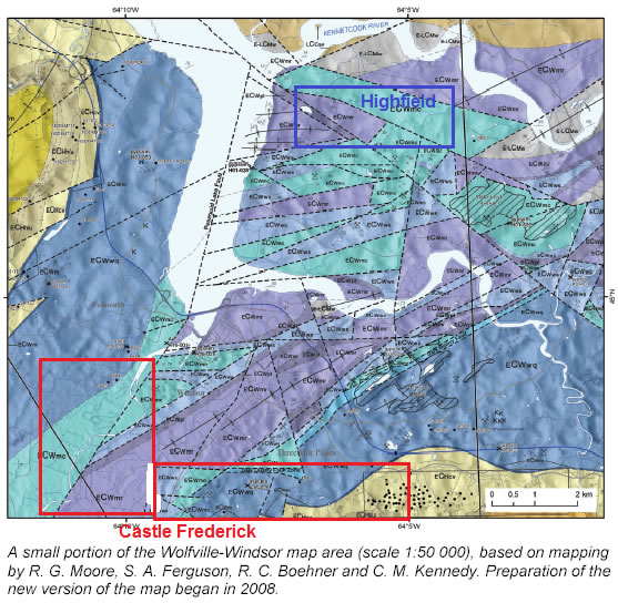
On the south banks of the Kennetcook river is a sliver of the Westphalian aged Scotch Village Formation whose undeformed but tilted gray green sandstone extend north to predominate on the northern bank and extend to the heart of the Kennetcook valley. Underlying and unconformable to the Scotch Village Formation and flanking its exposure on the south side are faulted blocks of the Lower Namurian aged Watering Brook Formation. Watering Brook Formation’s deformed grey siltstone with minor gypsum grades conformably into the underlying Upper Visean aged Murphy Road Formation a deformed reddish siltstone with abundant gypsum and limestone.
Over by the Avon estuary there is a faulted block of the Middle Visean Wentworth Station Formation with deformed dolstone limestone and gypsum have structurally broken through the succession. Further east the Middle Visean aged Pesaquid Lake Formation with its deformed reddish sandstones and limestone conformably underlies the Murphy Road Formation. Finally near the claims southern limits is the faulted and uplifted block of the Lower Visean aged Miller Creek Formation with its deformed greyish gypsum, limestones and dolstones. These are the compositions of the exposed bedrock in and around the immediate vicinity if the Highfield claim block.
In the succession of the Windsor sub-basin underlying the Miller Creek Formation but nowhere exposed at surface on this property would be the Lower Visean aged White Quarry Formation’s massive anhydrite. Under the White Quarry’s anhydrite would be the Early Visean aged Macumber Formation’s limestone. It is the Macumber Formation’s limestones that would be the host rock for the mineralization sought in this program. The Macumber’s limestones should be underlain by the Tournasian aged Horton Bluffs Formation’s shales siltstones and sandstones. The Horton Bluffs sediments are underlain by the basin’s metasedimentary floor of the Meguma core platform.
Structural Geology of the Claim Block
On the surface, the property’s predominant structure is a syncline in the lowlands near the Kennetcook River plunging gently by ~ 10º towards the east-northeast, this is constrained within two dominate east-northeast faults entering from the west and east end of the property. The surface structure is complex because of a northwest oriented central block faulted uplift, which is intersected with acute segments to create an extensive chaotic terrain to the south that implies a prior structure underlying the property. A regional Aeromagnetic survey has outlined a regional anticline in the Meguma basement floor of this basin area. The surface deformation is based on the tectonic thrust nappe that was emplaced between 318 to 315 m.y.a.
SUBSURFACE GEOLOGY OF THE PROPERTY
Observations in our recent drill hole confirm that there is in the composition between 438 to 445 m the appearance of a limy shale that converts into a limestone grit speckled with pelitic grits which at the base are boulders of organic rich limestone, the sequence is strongly characteristic of a talus skree (the rubble that forms at the base of a scarp).
At the 605 to 640 m depth the compression and hardening of the sediments have markedly increased, which is to be expected with the anticline rising to form a wall front to compress the south thrusted sedimentary blanket. The differential of the deformation deeper in the hole is consistent to a primary blanket’s (Devono-Carboniferous sediment) compression into a subsurface scarp wall (anticline’s northern flank). Both the change in deformation and the Macumber architecture place us in the proximity (within a couple of hundred meters) of the anticline’s nose. The assays of the fissure fills are not exceptional other than to prove the fissures were conduits of the metal carrying plumbing system and they are oriented towards the anticline. Of more significance with the assays was the high metal content of the limestone boulders, which is a surprise, as they do not appear to hold much metal sulfides, however it does hold promise. Thus now established from the drilling so far at the Highfield site we have a fissure system providing the plumbing for metal bearing brines. And 13 km to the southwest of the Highfield site at Castle Frederick we have the post development secondary calcite and selenite of the post?ore alteration. The Gay’s River mine coincides with the juncture of a north?northeast fault and the near contemporaneous east?northeast faults that serve as the regional conduits for metal bearing brine migration.
The core recently drilled at The Highfield, there are three such mineralized north?northeast faults intersecting the Avon peninsula Meguma anticline axis and two east?northeast faults intersecting the anticline axis acutely. Therefore, not only does this site possess the host rock condition, it also possesses the preferential plumbing orientation for the metal bearing brines, which is now confirmed by galena, siderite, chalcopyrite, pyrite, dolomite fissure fills. Mining engineers who worked for Esso Minerals at Gay’s River when it was operational, with their experience at the Gays River Mine upon seeing our core’s types of fissure filled mineralization, especially with the galena, in the arkosic sandstones recognized it to be remarkably similar to what they saw indicated in the abyssal part and about 150 m north of the Gays River ore body.
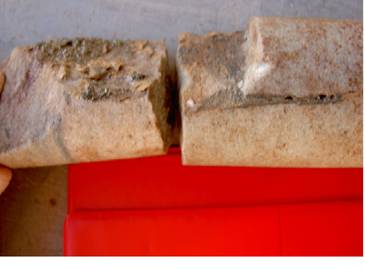
Fissure fill orients SSW, a small segment of 90cm vein
Two more observations further strengthen the case. One is the mineralized fissure fills identified at 644 m (30cm), 642.3 to 643.6 m, 586 m (5cm), and 587.2 m. These were identified as forming at the end of deformation, possibly its final phase. We note that the fissures cross and overprint the WSW-ENE extensional fractures. The other important observation that strengthens a high volume penetration of metal bearing brines is in the immediate surrounding vicinities to the south the host rock that demonstrates post?ore alteration mineralogy.
The exploration program set out to demonstrate that a set of predicted parallels to the Gay’s River mine could be proven to exist. If they could be proven, this would set the stage for the next phase of exploration program. The program was quite successful in demonstrating that:
- the anticline does exist
- the mechanism of metal entry to the anticline does exist, and,
- there is a high probability that a biohermal reef was situated on the nose of that anticline
- there is conclusive evidence that Mississippi Valley type mineralization exists on the property.
The mineralization is identified in fissure veins in the underlying continental granite sourced sediments whose brittleness favoured that sedimentary bed to be a conduit for the over pressured brines to escape to zones of lower pressure on the upper fringes of the basin. The marked increase to fold intensity, deformation, and bed hardness below the 500 m depth of the core is an indicator that the sediment pile has been compressed by both hydrostatic load and lateral compression against a scarp wall. Add to that the assemblage between 438 – 445 meters of the lime rich talus material composed of both limestone rich boulders with a mix of lime and pelitic sands suggest that the scarp top is within ? 150m to the south. Finally, the organic rich limestone boulders ? 1 m in size identified in the core is only likely to have formed in a shelf like biohermal provenance. However, there has been serious deformation in this area, a phase 1 S1 of compression, a phase 2 S2 of elongate lateral shift, a phase 3 S3 of extension and phase 4 S4 of elongate lateral distension (mineralization is in the phase 4). This back and forth, rocking side to side could well fragment, compress, shear down the reef, either spreading it out or compacting it or displacing it.
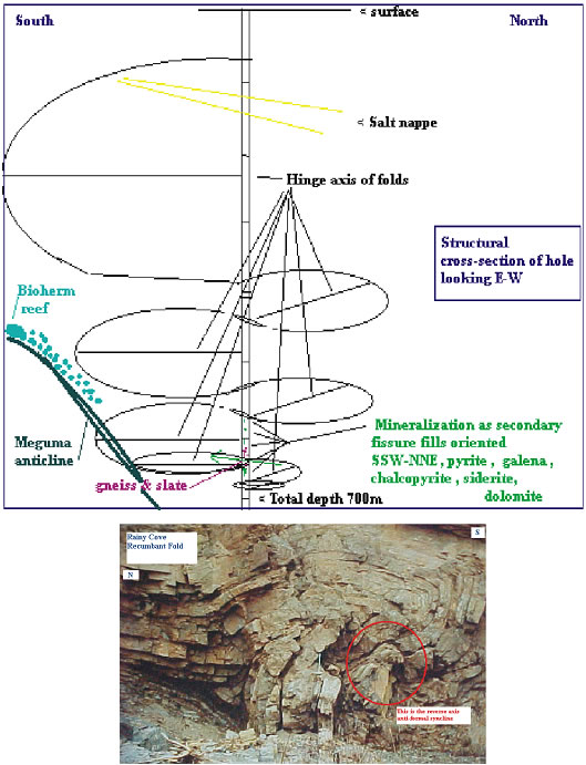
The following diagram combines the structural cleavage patterns in their relative positions logged from the #3 hole, it also demarks the zones of metamorphism and the mineralized fractures so observed. There is also a photo from Rainy Cove illustrating pumpellyians trend.


